Hurricane Erin continues its movement through the waters of the Caribbean and it is expected to increase its strength by Friday to become a hurricane.
However, the effects on Puerto Rico will not be direct, although it is expected to bring a large amount of rain to the island over the next few days and cause dangerous sea conditions.
PUBLICIDAD
Due to the large amount of rain expected for the island, a flash flood watch has been issued.
11:00am Bulletin
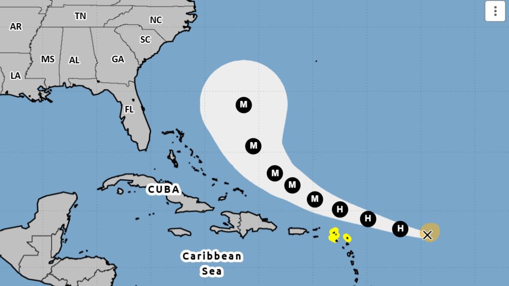
The system became the first hurricane of the 2025 season.
It is located at latitude 18.2 north, longitude 56.1 west.
Maximum sustained winds: 75 miles per hour
Movement: To the west-northwest at 18 miles per hour
Everything you need to know about tropical storm Erin
There is a high risk of life-threatening rip currents, dangerous breaking waves, and hazardous marine conditions across local waters and coastlines as the center of Erin moves northeast and then north of the region.
According to the most recent trajectory, it is expected that the closest point will be around 193 miles north-northeast of San Juan, Puerto Rico, and 166 miles north-northeast of St. Thomas, USVI.
What are the potential risks of the system?
Marine currents: Large breaking waves will produce potentially deadly marine currents and possible minor coastal flooding on beaches facing north and east of all islands, where a High Risk of Marine Currents and a Dangerous Wave Warning will be issued from this weekend until early Monday morning.
Dangerous surf with waves between 10 and 12 feet in the exposed waters of the Atlantic and the Anegada Passage from Saturday night to Sunday. Minor coastal erosion may occur.
Winds: Strong gusts of wind around 40 mph with the heaviest downpours.
Rainfall: An increase in showers and thunderstorm activity will begin late tonight and extend into early next week, especially as Erin moves north-northwest of the region.
Precipitation of 1 to 2 inches with isolated totals of 4 inches is expected in northwest Puerto Rico, and 2 to 4 inches with isolated totals of 6 inches in the south and east of Puerto Rico, as well as in Vieques, Culebra, and the U.S. Virgin Islands. Therefore, a Flash Flood Watch has been issued.
The National Hurricane Center (NHC) issues complete advisories at 5:00 a.m., 11:00 a.m., 5:00 p.m., and 11:00 p.m., in addition to intermediate updates at 2:00 a.m., 8:00 a.m., 2:00 p.m., and 8:00 p.m.
The hurricane season in the Atlantic begins on June 1st and ends on November 30th.
On August 6th, the Colorado State University (CSU) updated its seasonal forecast. The Tropical Cyclones, Radar, Atmospheric Model, and Software (TC-RAMS) team from the Department of Atmospheric Sciences at CSU suggested that the Atlantic hurricane season will be slightly above average.
According to the report, 16 tropical storms could form, of which eight would become hurricanes, including three of category three or higher, meaning with sustained winds of 111 miles per hour (mph) or more on the Saffir Simpson Scale.
“The tropical Atlantic has warmed faster than normal over the past few weeks, due to relatively weak winds blowing in the area, which has led to less evaporation and mixing of the ocean’s surface waters. Warmer than normal waters in the tropical Atlantic and the Caribbean Sea tend to favor an above-average hurricane season, as the fuel source for a hurricane is the warm ocean water. Additionally, a warm Atlantic results in lower atmospheric pressure and more atmospheric instability. Both conditions favor the formation of hurricanes,” the educational institution detailed in a press release.
The document indicates that there is a 52% probability of a hurricane making landfall in the Caribbean. The team also predicted that cyclonic activity in 2025 will be approximately 115% of the average season from 1991 to 2020.
On the other hand, meteorologist and researcher Philip Klotzbach indicated that, so far, the 2025 hurricane season exhibits similar characteristics to those of 2001, 2008, 2011, and 2021. He also mentioned that this year there is more uncertainty in the August forecasts than last year, due to the high wind shear in the Caribbean during June and July.
“There is still some uncertainty about what phase the ENSO (El Niño/Southern Oscillation) phenomenon will be in during the peak of the Atlantic hurricane season, from August to October, but the chances of El Niño are quite low—6% according to the latest forecasts from the National Oceanic and Atmospheric Administration (NOAA),” Klotzbach added.
The ENSO phenomenon refers to neutral conditions, which means that neither “El Niño” nor “La Niña” are present to influence cyclonic activity.
On the other hand, NOAA stated on August 7th that atmospheric and oceanic conditions continue to favor an “above-normal” season.
The federal agency updated the expected number of named systems to be between 13 and 18 (with winds of 39 mph or higher), of which between five and nine could become hurricanes (winds of 74 mph or higher), including between two and five major hurricanes (winds of 111 mph or higher).
In the Atlantic basin, an average season produces 14 named storms, of which seven become hurricanes and three become major hurricanes.
The chances of an “above-normal” season are 50%, with a 35% probability of an “almost normal” season and a 15% probability of a “below-normal” season.
The names that will be used for the systems in 2025 are: Fernand, Gabrielle, Humberto, Imelda, Jerry, Karen, Lorenzo, Melissa, Nestor, Olga, Pablo, Rebekah, Sebastien, Tanya, Van, and Wendy.
Four systems have formed so far: Andrea, Barry, Chantal, Dexter, and Erin.
What is the difference between a probability area of formation and a cone of uncertainty?
The area of probability formation is a region identified on maps where it is likely that a tropical cyclone will develop in the near future, usually within a timeframe of 48 hours to 7 days.
“This is not a track forecast. It represents the area of possible development of a tropical cyclone. It also includes a categorical forecast of the probability of formation, represented by a color scale indicating low (yellow), medium (orange), or high (red) probabilities of formation,” according to the National Weather Service (NWS).
The area is commonly represented as an oval on maps and classified according to the likelihood of formation in percentages. For example, low probability (less than 40%), medium probability (40%-60%), and high probability (more than 60%).
On the other hand, the Cone of Uncertainty refers to the projection of the possible path of an already formed tropical cyclone. Once it has been identified and named, a cone is drawn on the maps to indicate where the center of the storm could move in the coming days.
The cone width is based on historical forecast errors; it is narrower near the current point of the storm and widens as it projects into the future. It contains the likely path of the tropical cyclone center and shows the forecast for up to five days, in 12-hour intervals.
In March of this year, the National Hurricane Center (NHC) detailed that the margin of error in the trajectory of tropical cyclones will be between 3% and 5% smaller compared to 2024.
The size of each circle is established so that two-thirds of the historical errors of the official forecasts during the last five years (2020-2024) fall within the circle.